Groundwater and Data: Aquafuture’s Remote Sensing Method and the Importance for Indonesia
Satellite Remote Sensing Technologies for Groundwater Detection and Monitoring: Strategic Implications and Implementation Framework for Indonesia's Water Resource Management
Reading Time: 20 minutes
Key Highlights
• Critical Challenge: Indonesia faces mounting groundwater stress from urbanization, industrial growth, and climate variability, with subsidence and saline intrusion threatening major coastal cities.
• Technology Solution: Satellite remote sensing integrates gravitational, optical, and radar data to map aquifer locations, monitor depletion rates, and assess sustainability without invasive surface exploration.
• Proven Performance: International applications demonstrate exploration success rates exceeding 80 percent compared to 50-70 percent with conventional methods, substantially reducing investment risk.
• Strategic Partnership: Recent collaboration between SUPRA International and Aquafuture Solutions brings advanced satellite-based groundwater detection capabilities to Indonesian markets.
Executive Summary
Groundwater supplies approximately half of global drinking water and nearly half of irrigation water for agriculture. In Indonesia, dependence on this invisible resource runs even deeper. Municipal water systems from Jakarta to Surabaya draw predominantly from wells. Manufacturing clusters across Java rely on groundwater for production processes. Agricultural regions pump from aquifers when surface water proves insufficient or unreliable. This dependence creates vulnerability when conventional exploration methods carry high failure rates and provide limited insight into long-term sustainability.
The warning signs of stress are visible in multiple locations. Jakarta experiences subsidence rates among the highest globally, with some areas sinking more than 10 centimeters annually.[1] Coastal aquifers face saline intrusion as freshwater levels drop below sea level. Agricultural regions see falling water tables that force farmers to drill deeper or abandon wells entirely. These conditions demand better tools for finding new sustainable sources and managing existing resources.
Satellite remote sensing has emerged as a powerful approach to groundwater exploration and management. Technologies including GRACE gravitational satellites, Landsat multispectral imaging, and SAR radar systems provide data on subsurface conditions that correlate with aquifer presence and health.[2] These methods reduce exploration risk, enable continuous monitoring, and support data-driven decisions about sustainable extraction rates. This article examines how satellite technology can address Indonesia's groundwater challenges and outlines practical implementation considerations for various sectors.
Indonesian Groundwater Sector: Current Status and Pressures
Understanding the specific context of groundwater use in Indonesia provides essential background for evaluating technological solutions. The country's groundwater situation differs from many other regions due to its unique combination of geological diversity, rapid development, and regulatory challenges.
Geological conditions vary dramatically across the archipelago. Volcanic islands like Java and Bali feature permeable formations that can store and transmit substantial water volumes. Limestone areas in Nusa Tenggara and parts of Sulawesi contain karst aquifers with complex flow patterns. Coastal alluvial plains hold shallow aquifers vulnerable to contamination and saltwater intrusion. This geological diversity means that no single exploration or management approach works everywhere.
Demand drivers compound the technical challenges. Population growth concentrates in urban areas already experiencing water stress. Industrial expansion, particularly in manufacturing and food processing, increases water requirements. Agricultural intensification to feed growing populations relies heavily on irrigation. Climate variability adds uncertainty, with prolonged dry seasons reducing natural recharge rates in many regions.
The regulatory framework continues to develop but faces implementation challenges. National and local regulations establish principles for sustainable groundwater management, but monitoring capacity remains limited. Data collection occurs through various agencies without consistent integration. Enforcement of extraction permits and sustainability requirements varies significantly across regions. These institutional gaps mean that even good technical information may not translate into better management without parallel governance improvements.
Key Groundwater Challenges in Indonesia:
Urban Subsidence and Coastal Vulnerability:
• Jakarta sinking at rates exceeding 10 cm per year in some districts
• Semarang, Bandung, and other cities experiencing measurable subsidence
• Saline intrusion affecting coastal aquifers in multiple provinces
• Infrastructure damage from differential settlement creating economic costs
• Increased flood risk as land surface drops relative to sea level
Agricultural Water Security:
• Falling water tables in intensive irrigation areas
• Increased drilling depths raising costs for small farmers
• Reduced well yields forcing new exploration or crop changes
• Seasonal scarcity during extended dry periods
• Competition between agricultural and urban users
Industrial Supply Reliability:
• Manufacturing hubs dependent on groundwater for operations
• Quality concerns from contamination in heavily developed areas
• Uncertainty about long-term availability affecting investment decisions
• Need for multiple source diversification increasing costs
• Regulatory compliance requirements for sustainable extraction
Data and Monitoring Gaps:
• Limited coverage of hydrogeological surveys across regions
• Fragmented data collection among government agencies
• Insufficient monitoring of extraction rates and aquifer levels
• Lack of integrated information systems for management decisions
• Uneven regulatory enforcement and permitting oversight
Satellite Remote Sensing: Technology Fundamentals
Satellite remote sensing for groundwater applications rests on measuring surface and near-surface phenomena that correlate with subsurface hydrological conditions. While satellites cannot directly observe aquifers deep underground, they detect proxies including gravitational variations, surface moisture patterns, vegetation health, and land deformation that provide valuable insights about groundwater presence and dynamics.
Three primary satellite technologies serve groundwater investigations. GRACE (Gravity Recovery and Climate Experiment) and its successor GRACE-FO measure minute changes in Earth's gravitational field caused by mass redistribution, including variations in water storage.[3] These satellites orbit in tandem, with precise distance measurements between them revealing gravitational anomalies. When groundwater storage increases in a region, the additional mass creates a slight gravitational pull that brings the satellites closer together. Monthly data enables tracking of seasonal cycles and long-term trends in groundwater storage at regional scales.
Optical multispectral satellites like Landsat and Sentinel-2 observe surface reflectance across visible and infrared wavelengths. Different materials reflect light distinctively, creating spectral signatures useful for identifying geological formations, soil moisture, and vegetation conditions. Areas with shallow groundwater often support lusher vegetation that shows up in near-infrared bands. Certain rock types associated with productive aquifers exhibit characteristic spectral patterns. Google Earth Engine platforms have made these satellite images more accessible for water quality monitoring and environmental assessment applications in Indonesia.[4]
Synthetic Aperture Radar (SAR) systems transmit microwave pulses and measure the reflected signals. SAR works through clouds and darkness, providing consistent coverage in tropical regions like Indonesia. Interferometric SAR (InSAR) compares images from different dates to detect surface deformation with millimeter precision. When aquifers lose water, the reduction in pore pressure causes soil and rock to compact, leading to measurable subsidence. Indonesian research institutions including BRIN have utilized SAR data for various geoinformatics applications relevant to environmental monitoring and resource management.[5]
Hyperspectral and AI Integration
Beyond the established satellite technologies, newer developments enhance groundwater detection capabilities. Hyperspectral satellites carry sensors with hundreds of narrow spectral bands rather than the dozen or fewer bands on conventional multispectral satellites. This detailed spectral information enables more precise identification of minerals, soil types, and water quality parameters.[6]
Provincial governments in Indonesia have begun exploring hyperspectral technology. Lampung province signed cooperation agreements to utilize hyperspectral satellites for mapping soil moisture and agricultural parameters, applications directly relevant to groundwater prospecting.[7] The technology remains more expensive than conventional satellites but costs continue to decline as more countries and companies launch hyperspectral systems.
Artificial intelligence and machine learning algorithms have become integral to processing satellite data for groundwater applications. The volume of imagery available from multiple satellite constellations exceeds human capacity for manual analysis. Machine learning models trained on areas with known aquifer conditions can identify patterns in satellite data that correlate with groundwater presence. These models process terrain characteristics, spectral signatures, historical climate data, and geological information to generate probability maps showing areas most likely to contain productive aquifers.
Recent research demonstrates that remote sensing technologies can unlock new capabilities for groundwater monitoring and management.[8] The integration of coarse-resolution gravity data with high-resolution surface deformation measurements from radar provides enhanced characterization of groundwater changes. Cloud computing platforms enable intensive analysis of large geospatial datasets, addressing technical challenges that previously limited operational applications.
Data Sources and Integration for Groundwater Assessment:
Satellite Observations:
• GRACE/GRACE-FO gravitational data for regional storage changes
• Landsat and Sentinel-2 multispectral imagery for surface indicators
• SAR (Sentinel-1, ALOS-2) for deformation and moisture detection
• Hyperspectral satellites for detailed geological and soil analysis
• Digital elevation models from SRTM, ALOS, and TanDEM-X missions
Geological and Hydrological Data:
• Geological maps showing formations and structures
• Existing borehole logs and well completion reports
• Historical water level measurements where available
• Soil surveys and permeability data
• Hydrogeological studies and aquifer characterizations
Climate and Environmental Information:
• Precipitation records from ground stations and satellite estimates
• Evapotranspiration data from land surface models
• Land cover classifications from satellite imagery
• Surface water extent and seasonal variations
• Temperature and humidity measurements
Anthropogenic Factors:
• Population distribution and urbanization patterns
• Industrial facility locations and water use estimates
• Agricultural land use and irrigation practices
• Existing groundwater extraction permits and reported usage
• Wastewater discharge and pollution source mapping
Applications for Groundwater Exploration
The transition from satellite data to actionable information for groundwater exploration requires systematic methodology. The process typically begins with defining the geographic area of interest and the objectives of the investigation. Different applications demand different approaches and levels of detail.
Regional reconnaissance surveys cover large areas to identify promising zones for more detailed investigation. At this scale, GRACE data reveals broad patterns of groundwater storage changes. Multispectral imagery identifies major geological provinces and large-scale structural features. Digital elevation models show topographic patterns that influence recharge and discharge. The output guides where to focus subsequent detailed studies, preventing wasted effort in areas with low probability of success.
Site-specific exploration for individual projects requires higher resolution analysis. High-resolution optical and radar imagery reveals smaller geological structures and local terrain features. Machine learning algorithms trained on regional data generate probability maps at scales relevant for well placement decisions. Integration with geological maps and any existing well data refines the assessment. The final product typically includes priority drilling locations ranked by confidence level, estimated depth ranges, and expected yield capabilities.
Research institutions in Indonesia have demonstrated capacity to apply these technologies. Studies by Universitas Gadjah Mada's Geodesy Department have examined spatial relationships of groundwater table fluctuations using GRACE satellite data, particularly in peatland environments.[9] Other research has explored precision irrigation systems that can integrate satellite-derived moisture data for optimized water management.[10]
Monitoring and Sustainability Assessment
Finding new groundwater sources addresses only part of the challenge. Long-term sustainability requires continuous monitoring of aquifer conditions and extraction rates. Satellite technology provides cost-effective monitoring capabilities across large areas, complementing traditional point measurements from wells.
InSAR measurements of land subsidence serve as an early warning system for aquifer overdraft. When extraction exceeds recharge, pore pressure declines cause measurable surface lowering. Regular InSAR monitoring can detect acceleration in subsidence rates that indicates increased stress on the aquifer system. This information enables management intervention before depletion becomes severe or irreversible damage occurs to the aquifer structure.
GRACE data tracking regional groundwater storage provides a different perspective on sustainability. While monthly temporal resolution limits utility for short-term operational decisions, the data excels at revealing long-term trends and seasonal patterns. Comparison of current storage levels against historical baselines shows whether a region maintains equilibrium between extraction and recharge or experiences net depletion. International research has established methods for using GRACE data to monitor groundwater levels in conjunction with hydrological models.[3]
Vegetation indices derived from multispectral satellite imagery offer another sustainability indicator. Areas where groundwater-dependent vegetation shows stress or decline may signal falling water tables. Agricultural areas experiencing yield reductions despite normal rainfall could indicate aquifer depletion affecting irrigation supplies. These indirect indicators complement direct hydrological measurements and can flag problems in areas lacking dense monitoring networks.
Comprehensive sustainability assessments integrate monitoring data with recharge estimates and extraction records. Satellite-based rainfall estimates combined with land cover information enable modeling of natural recharge rates. Comparison against known or estimated extraction volumes reveals whether current use remains within sustainable limits. The analysis can support regulatory decisions about new permits, extraction limitations, or requirements for artificial recharge measures.
Case Studies: International Experience and Performance
Evidence from international applications demonstrates both the capabilities and limitations of satellite-based groundwater technology. Understanding real-world performance helps set realistic expectations for implementation in Indonesia.
California's Central Valley provides one of the most extensively documented cases of satellite monitoring for groundwater management. Research using InSAR and GRACE data quantified substantial aquifer depletion during prolonged drought periods.[1] The measurements revealed subsidence rates exceeding 30 centimeters per year in heavily pumped areas, prompting regulatory action to limit extraction. The technology provided objective data supporting difficult policy decisions about water allocation.
Applications in Africa and South Asia have focused more on exploration for new sources rather than monitoring existing development. Projects in these regions report improved success rates when satellite analysis informs drilling locations. While traditional methods might achieve 50 to 70 percent success rates, integration of remote sensing data has pushed success above 80 percent in some programs. The improvement translates directly to reduced costs and faster development of reliable water supplies.
Latin American applications span both exploration and monitoring. In Chile and Argentina, satellite technology has supported water resource development for mining operations in remote arid regions. In Brazil, monitoring of the Guarani Aquifer system uses satellite data to track extraction impacts across multiple states. These varied applications demonstrate technology adaptability to different geological settings and management objectives.
The common element across successful applications is integration with local geological expertise and field verification. Satellite technology reduces uncertainty and guides decision-making, but does not eliminate the need for hydrogeological interpretation and targeted field investigation. The technology works best when combined with traditional methods rather than replacing them entirely.
Implementation Pathways for Indonesian Context
Bringing satellite-based groundwater technology into operational use in Indonesia requires addressing specific technical, institutional, and economic factors. The path forward must account for local geological complexity, existing capacity, and regulatory frameworks.
Technical adaptation begins with calibrating analytical methods to Indonesian geological conditions. Volcanic formations common in Java and Bali behave differently from limestone karst systems or coastal alluvial aquifers. Machine learning algorithms trained on data from other regions may not perform optimally without local calibration. Building Indonesian reference datasets that link satellite observations with known aquifer characteristics enables better predictions in similar geological settings.
Institutional development involves strengthening data infrastructure and analytical capacity. Satellite imagery and processing tools increasingly available through cloud platforms reduce technical barriers. However, effective use requires trained personnel who understand both remote sensing technology and hydrogeology. Universities and research institutions can play important roles in developing expertise and conducting validation studies that build confidence in the methods.
Recent developments indicate growing interest in these technologies at various levels. Provincial initiatives like Lampung's satellite cooperation agreement demonstrate sub-national recognition of remote sensing value for resource management. National agencies including BRIN continue expanding geoinformatics capabilities relevant to environmental monitoring. The Indonesia Meteorology, Climatology and Geophysics Agency (BMKG) has emphasized innovation in early warning systems to address climate and disaster risks toward Indonesia's development goals, representing broader institutional commitment to data-driven approaches.[11]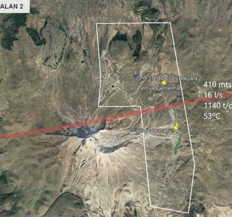
A significant development in bringing advanced groundwater detection technology to Indonesia is the recent partnership between SUPRA International and Aquafuture Solutions. Aquafuture, a Barcelona-based consultancy specializing in satellite-based groundwater location, has developed proprietary methods combining artificial intelligence with data from multiple satellite sources including Sentinel, Landsat, and LIDAR systems. Their remote sensing approach claims exploration success rates exceeding 90 percent and can estimate depth, flow rate, and water temperature before drilling begins. The company's focus on identifying continuously recharged groundwater veins rather than limited aquifers aligns with sustainability priorities. Through the partnership, SUPRA International brings Aquafuture's technology and methodology to Indonesian markets, adapted to local geological conditions and regulatory requirements. This collaboration represents a practical pathway for companies and government entities to access proven satellite-based exploration methods without developing in-house capabilities from scratch.
Strategic Implementation Framework for Indonesian Sectors:
Industrial Water Supply Development:
• Use satellite reconnaissance to identify potential source areas near planned facilities
• Integrate remote sensing with geological surveys for site-specific exploration
• Design monitoring programs combining satellite and ground-based measurements
• Establish sustainability assessments based on recharge calculations
• Develop contingency plans if satellite data indicates long-term decline risks
Municipal Water Security Planning:
• Conduct regional assessments of aquifer conditions and trends
• Prioritize areas for new wellfield development based on sustainability criteria
• Implement continuous InSAR monitoring for subsidence tracking
• Support allocation decisions with objective data on resource availability
• Enhance public communication about groundwater conditions and management needs
Agricultural Water Management:
• Map irrigation water availability at district and sub-district scales
• Identify areas where groundwater development can support food security
• Monitor extraction impacts in intensive irrigation zones
• Guide farmers toward areas with better long-term water availability
• Integrate satellite soil moisture data with irrigation scheduling systems
Regulatory and Governance Support:
• Establish standardized methods for satellite data use in permit decisions
• Build capacity in relevant agencies for technology application
• Create data sharing protocols between government levels
• Develop enforcement mechanisms linked to monitoring results
• Ensure transparent communication of technical findings to stakeholders
Economic Considerations and Investment Analysis
The economic case for satellite-based groundwater technology balances upfront analysis costs against risk reduction and efficiency gains. For project developers and policymakers, understanding this economic equation guides decisions about technology adoption.
Direct costs for satellite analysis vary with project scale and required detail. Regional assessments covering hundreds or thousands of square kilometers cost substantially less per unit area than site-specific studies. For individual industrial or municipal projects, satellite analysis typically represents a small fraction of total development costs, often less than the expense of drilling a single exploratory well. When analysis reduces the number of unsuccessful wells, the cost savings quickly exceed the analysis investment.
Risk mitigation value extends beyond direct drilling costs. An unsuccessful well represents schedule delays and potentially forces use of more expensive alternative water sources. For water-intensive industries, production delays from water supply problems translate to lost revenue. Satellite technology that increases confidence in source reliability reduces these risks, making projects more bankable and potentially lowering financing costs.
Long-term operational benefits come from better resource management. Wells developed with comprehensive understanding of aquifer characteristics can be designed for optimal productivity and longevity. Monitoring systems informed by satellite data detect problems early, enabling preventive action rather than expensive emergency responses. Sustainability assessments help avoid overdevelopment that leads to rapid depletion and premature well failure.
Broader economic value accrues from improved water security across sectors. Manufacturing facilities with reliable water supplies can operate consistently and plan expansion with confidence. Agricultural regions with sustainable irrigation sources achieve stable production rather than boom-bust cycles. Cities with well-managed groundwater avoid subsidence damage to infrastructure and maintain diverse supply portfolios. These macroeconomic benefits justify public investment in technology adoption and capacity building even when individual project economics are less clear.
Challenges and Limitations
Realistic assessment of satellite technology for groundwater applications requires acknowledging current limitations and ongoing challenges. Understanding these constraints helps set appropriate expectations and identifies areas needing continued development.
Spatial resolution constraints affect all satellite systems. GRACE data operates at regional scales, typically requiring areas exceeding 150,000 square kilometers for reliable measurements. This resolution suffices for broad trend analysis but cannot resolve conditions at individual wellfield scales. Optical and radar satellites offer much finer spatial resolution but still may miss small-scale features relevant to groundwater flow. Integration of multiple data sources helps address this limitation but does not eliminate it.
Temporal resolution presents another challenge. GRACE provides monthly snapshots, adequate for long-term trends but insufficient for operational management requiring more frequent updates. Optical satellites face cloud interference in tropical regions, creating gaps in temporal coverage. SAR overcomes cloud problems but revisit times still limit how quickly changes can be detected. Satellite constellations with multiple spacecraft improve temporal coverage but increase data processing requirements.
Interpretation uncertainty arises from the indirect nature of satellite measurements. Satellites observe surface phenomena that correlate with but do not directly measure groundwater conditions. The relationships between satellite observables and aquifer parameters depend on local geology, which must be understood through traditional methods. Machine learning models trained on limited calibration data may not generalize well to different geological settings without additional validation.
Technical capacity requirements should not be underestimated. Effective use of satellite data demands expertise in remote sensing, hydrogeology, and data analysis. Processing large datasets requires appropriate computing infrastructure. Indonesia has relevant expertise in universities and research institutions, but scaling up to meet operational demands across multiple sectors requires sustained investment in training and infrastructure.
Validation remains an ongoing need. Confidence in satellite-based assessments grows when predictions can be verified against drilling results and long-term monitoring. Building validation datasets specific to Indonesian geological settings requires time and systematic data collection. Early applications should include verification components that test predictions and refine methods based on outcomes.
Future Developments and Long-term Outlook
The trajectory of satellite remote sensing technology points toward continued improvement in capabilities relevant to groundwater management. Understanding likely future developments helps guide current investment decisions and long-term planning.
Next-generation satellite systems promise enhanced resolution and more frequent observations. GRACE Follow-On improvements increase measurement precision. New SAR constellations provide daily or even multiple daily coverage of the same areas. Hyperspectral satellite deployments expand globally, with decreasing costs making the technology more accessible. These technical advances will enable detection of smaller-scale features and shorter-term changes relevant to operational groundwater management.
Artificial intelligence capabilities continue advancing rapidly. Machine learning models become more sophisticated at extracting information from complex datasets. Integration of satellite data with other information sources through AI enables more comprehensive assessments. Cloud computing platforms democratize access to processing power, allowing smaller organizations to utilize advanced analytical methods previously available only to major research institutions.
International cooperation and data sharing improve accessibility. Many satellite programs provide free data access for scientific and management applications. Global initiatives promote standardized methods and shared best practices. Indonesia can benefit from these trends by participating in international programs and ensuring that local datasets contribute to global knowledge while serving domestic needs.
Integration with Internet of Things (IoT) sensors creates opportunities for hybrid monitoring systems. Ground-based sensors measuring water levels, quality parameters, and extraction rates can be combined with satellite observations in real-time data platforms. This integration provides more complete situational awareness than either technology alone. Indonesia's growing digital infrastructure supports development of these integrated systems.
The long-term outlook suggests that satellite-based groundwater technology will transition from specialized research application to standard management tool. Organizations that develop capabilities now will be positioned to take full advantage as the technology matures. Those that delay may find themselves at competitive disadvantage as stakeholders increasingly expect data-driven decision-making about water resources.
Strategic Imperatives for Indonesian Groundwater Management
Indonesia faces mounting pressure on groundwater resources from population growth, economic development, and climate variability. Conventional exploration and management approaches prove inadequate when facing high failure rates, limited monitoring capacity, and insufficient data for sustainable allocation decisions. Satellite remote sensing technology offers a pathway to address these challenges through improved exploration efficiency, continuous monitoring capability, and better information for policy decisions.
The technology is not theoretical. International applications demonstrate measurable improvements in exploration success rates and provide objective data supporting difficult management decisions. Costs continue declining while capabilities improve. Indonesian institutions have begun exploring applications, and partnerships like the SUPRA-Aquafuture collaboration bring proven methodologies to local markets.
However, technology alone does not solve management problems. Satellite data must be integrated into governance frameworks that limit overdraft, protect recharge areas, and ensure equitable allocation. Monitoring must be paired with enforcement of sustainability requirements. Capacity building in both technical and institutional domains requires sustained investment. Public communication about groundwater conditions and management rationale builds support for necessary but sometimes unpopular decisions.
Five to ten years from now, the regions and sectors that treat groundwater as a strategic resource warranting data-driven management will be better positioned to handle climate variability, economic opportunities, and social pressures. Indonesia has the opportunity to move in this direction. The tools exist. The question is whether institutions, companies, and communities will use them effectively to secure water resources for long-term prosperity.
References
1. Nature Scientific Reports. Satellite-based monitoring of groundwater depletion in California's Central Valley.
https://www.nature.com/articles/s41598-019-52371-7
2. Space4Water. Space technologies in the detection, monitoring and management of groundwater.
https://www.space4water.org/news/space-technologies-detection-monitoring-and-management-groundwater
3. ScienceDirect. Monitoring of the Groundwater Level using GRACE with Hydrological Models.
https://www.sciencedirect.com/science/article/pii/S2667010024000404
4. Mahasiswa Indonesia. Pemanfaatan Teknologi Citra Satelit dan Google Earth Engine untuk Pemantauan Pencemaran Air.
https://mahasiswaindonesia.id/pemanfaatan-teknologi-citra-satelit-dan-google-earth-engine-untuk-pemantauan-pencemaran-air-tantangan-dan-peluang/
5. BRIN. Dukung Aplikasi Geoinformatika, Periset BRIN Manfaatkan Data SAR.
https://www.brin.go.id/press-release/122835/dukung-aplikasi-geoinformatika-periset-brin-manfaatkan-data-sar
6. XiOPM Space. Insight into the Earth's Eyes of Fire: Hyperspectral Remote Sensing Satellites.
https://www.xiopmspace.com/id/news/insight-into-the-earth-s-eyes-of-fire-hyperspectral-remote-sensing-satellites/
7. Pemerintah Provinsi Lampung. Gubernur Mirza Tandatangani Kerja Sama Pemanfaatan Satelit.
https://lampungprov.go.id/detail-post/gubernur-mirza-tandatangani-kerja-sama-pemanfaatan-satelit-dengan-perusahaan-teknologi-luar-angkasa-tiongkok
8. ScienceDirect. Remote Sensing Technologies for Unlocking New Groundwater Insights: A Comprehensive Review.
https://www.sciencedirect.com/science/article/pii/S2589915524000051
9. Geodesi UGM. Penelitian Hubungan Spasial Fluktuasi Muka Air Tanah Gambut menggunakan Satelit GRACE.
https://geodesi.ugm.ac.id/2025/02/
10. Jurnal Pertanian Teknologi Agroindustri. Inovasi Teknologi Pengelolaan Tanah dan Air untuk Irigasi Presisi berbasis Mikrokontroler.
https://jtam.ulm.ac.id/index.php/jpt/article/download/3233/1795/
11. BMKG. BMKG Terus Lakukan Inovasi Sistem Peringatan Dini Hadapi Risiko Iklim dan Bencana Menuju Indonesia Emas 2045.
https://www.bmkg.go.id/siaran-pers/bmkg-terus-lakukan-inovasi-sistem-peringatan-dini-hadapi-risiko-iklim-dan-bencana-menuju-indonesia-emas-2045
12. AGU Publications. Remote Sensing of Groundwater: Current Capabilities and New Directions.
https://agupubs.onlinelibrary.wiley.com/doi/10.1029/2022WR032219
13. CDU Research. An Overview of Groundwater Monitoring through Point-to-Satellite Technologies.
https://researchers.cdu.edu.au/en/publications/an-overview-of-groundwater-monitoring-through-point-to-satellite-
14. NRSC India. Groundwater Mapping and Potential Zones Identification Using Satellite Imagery.
https://www.nrsc.gov.in/sites/default/files/pdf/ebooks/Chap_8_GroundWater.pdf
15. Google Earth Engine Datasets. Pemetaan Air Permukaan Global JRC dan Landsat-derived Surface-Ground-Water.
https://developers.google.com/earth-engine/datasets/tags/geophysical?hl=id
 ×
× Satellite-Based Groundwater Detection Services for Indonesia
SUPRA International, in partnership with Aquafuture Solutions, provides comprehensive satellite remote sensing services for groundwater exploration and monitoring across Indonesia. Our collaboration brings proven European technology adapted to Indonesian geological conditions, supporting industrial water supply development, municipal planning, agricultural water security, and regulatory compliance.
Aquafuture's proprietary methodology combines artificial intelligence with multi-satellite data (Sentinel, Landsat, LIDAR) to identify groundwater sources remotely with success rates exceeding 90%. The technology estimates depth, flow rate, and sustainability before drilling, reducing exploration risk and optimizing investment decisions.
Need expert guidance on groundwater exploration or monitoring?
Contact SUPRA to discuss how satellite technology can support your water resource objectives
Share:
If you face challenges in water, waste, or energy, whether it is system reliability, regulatory compliance, efficiency, or cost control, SUPRA is here to support you. When you connect with us, our experts will have a detailed discussion to understand your specific needs and determine which phase of the full-lifecycle delivery model fits your project best.